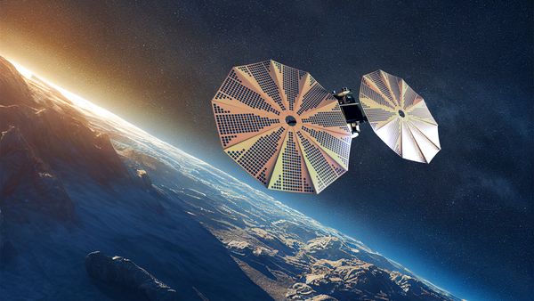
Three new Space42 satellites are now fully operational, expanding the UAE’s Earth observation network to five radar satellites.
Three advanced UAE satellites have gone live, strengthening the country’s ability to respond to disasters and track climate change. Abu Dhabi-based Space42 announced that Foresight-3, Foresight-4, and Foresight-5 are now fully operational after completing their commissioning and testing phases. The three satellites expand the company’s Foresight Earth Observation constellation to five Synthetic Aperture Radar, or SAR, satellites.
The trio launched into orbit in November 2025 aboard a SpaceX rocket from Cape Canaveral in Florida. They use advanced radar technology to capture high-resolution images of the Earth’s surface in all conditions, day or night. That capability lets the satellites see through cloud cover and operate in darkness, which makes them useful during emergencies when conventional optical imaging falls short.
The imagery feeds into GIQ, Space42’s AI-powered geospatial intelligence platform. The platform converts raw radar data into what the company calls decision-grade intelligence for governments, infrastructure operators, and industry. The system supports near real-time change detection, which allows authorities to spot shifts on the ground quickly during fast-moving events.
Foresight Satellites Deliver All-Weather Radar Imagery
The new satellites capture imagery at 25-centimeter resolution, a level of detail fine enough to support emergency management and infrastructure monitoring. Space42 placed Foresight-3, -4, and -5 in mid-inclined Low Earth Orbit to extend coverage and improve revisit rates. The orbit strengthens monitoring across regions where more than 90 percent of the world’s population resides.
Radar data from the constellation has already played a role in regional crises. The imagery helped confirm the safety of the Ataturk Dam after an earthquake in Turkey, and it supported the UAE’s response to the 2024 floods. In both cases, the all-weather capability allowed analysts to assess conditions on the ground when other forms of imaging were limited.
The expanded constellation increases coverage over key regions and improves how often the satellites can revisit a given area. Faster revisit times matter for disaster response, since they let operators track how a situation develops over hours rather than days.
UAE Satellites Built and Tested in Abu Dhabi
Space42 manufactured the three satellites in partnership with ICEYE, a Finland-based company that operates one of the world’s largest SAR satellite networks. The partnership supports technology transfer and helps localize the supply chain within the UAE. Space42 completed the integration and testing of the satellites at its Assembly, Integration and Testing facility in Abu Dhabi.
The work marked the first time advanced SAR satellites completed integration and testing inside the UAE. Space42 framed the achievement as a shift from reliance on imported technology toward building advanced platforms with global partners. The company said the milestone strengthens national capability to a level that competes across global markets.
Hasan Al Hosani, chief executive of Smart Solutions at Space42, said the new satellites raise the country’s standing in the sector. “With Foresight-3, -4, and -5 now live, we are expanding sovereign Earth observation with greater speed and consistency to governments, industries, and partners worldwide,” he said. He added that the collaboration with ICEYE and the operational success at the Space42 facility supported the company’s goal of becoming a preferred partner for premium geospatial data.
Earth Observation Tied to UAE Space Strategy 2030
The expansion aligns with the UAE’s National Space Strategy 2030, which guides the country’s investments in space infrastructure, manufacturing, and AI integration. The UAE is positioning itself as a global supplier of advanced Earth observation capabilities, and the Foresight constellation combines space-based data collection with AI-driven analytics to support that aim.
Demand for Earth observation data continues to climb as governments and industries turn to geospatial intelligence to manage risk and support climate and security objectives. By 2030, Earth observation insights are expected to generate more than 700 billion dollars in economic value across multiple sectors, according to industry estimates cited by Space42.
Space42 formed in 2024 through the merger of Bayanat and Yahsat. The company integrates satellite communications, geospatial analytics, and artificial intelligence, and it serves customers across governments, enterprises, and communities. The Foresight constellation began with a first launch in August 2024, followed by another in January 2025, before the November 2025 launch that added Foresight-3, -4, and -5.
The constellation now provides persistent, all-weather imagery for uses that range from disaster response and climate monitoring to urban planning, logistics, and national security.
Stay tuned for more updates and news!