

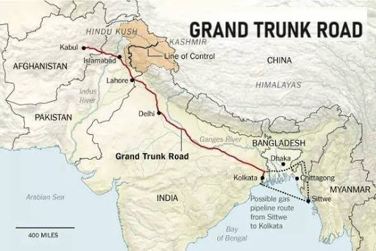
Long before railways, airports, and modern motorways connected South Asia, a single road linked kingdoms, cultures, and civilizations across the region. The Grand Trunk Road, often called the GT Road, is one of the oldest and longest continuously used highways in the world. Stretching for more than 2,500 kilometres across present-day Bangladesh, India, Pakistan and extending towards Afghanistan, it has served as the backbone of trade, administration and cultural exchange for over two millennia.
The origins of the route date back to the ancient Uttarapatha, a major trade corridor that existed as early as the 3rd century BCE during the Mauryan Empire. It connected the eastern city of Pataliputra (modern Patna) with Taxila, one of the ancient world’s greatest centres of learning located in Pakistan. Merchants, scholars, monks and travellers used this route to transport goods, spread ideas and connect distant kingdoms.
The road took its modern shape in the 16th century under the rule of Sher Shah Suri, who reconstructed and expanded the highway between Bengal and the Indus Valley. Recognising its strategic and economic importance, he introduced a network of sarais (roadside inns) for travellers, dug wells, planted shade trees and established postal stations at regular intervals. These improvements transformed the road into one of the most advanced transport networks of its time, facilitating both commerce and governance.
During the Mughal Empire, the Grand Trunk Road became an essential imperial artery, carrying armies, officials, merchants and pilgrims across the subcontinent. Markets flourished along its route, giving rise to thriving towns and cities that benefited from increased trade and cultural interaction.
The British Empire later modernised the road in the 19th century, strengthening bridges, improving road surfaces and extending sections further east. It was during this period that the route became widely known as the “Grand Trunk Road,” reflecting its role as the principal highway. The road played a vital role in military logistics, postal services and commercial transport throughout the colonial era.
Beyond its role as a trade and administrative artery, the Grand Trunk Road has long held a place in South Asia’s cultural imagination. Rudyard Kipling immortalized it in his novel Kim, describing it as “a river of life,” and over the centuries the road has been known by many names — Uttarapatha, Sadak-e-Azam, and Badshahi Sadak among them — before becoming known as the Grand Trunk Road. Several of its historic structures still stand as testaments to its layered past, including Rohtas Fort near Jhelum, a UNESCO World Heritage Site built by Sher Shah Suri, and Attock Fort, constructed under Emperor Akbar to guard a key crossing over the Indus River. The road also carried more than merchants and soldiers: Sufi pilgrims travelled its length to reach shrines along the way, while dak runners relayed imperial messages in a relay system that functioned as an early postal highway.
Today, the Grand Trunk Road remains an integral part of South Asia’s transport network. In Pakistan, large sections form part of the N-5 National Highway, connecting major cities such as Peshawar, Rawalpindi, Lahore and extending to the Wagah border. Many historic landmarks, caravanserais and centuries-old settlements still stand along its path, serving as reminders of its remarkable legacy.
More than just a road, the Grand Trunk Road represents the shared history of South Asia. For centuries, it carried not only goods and armies but also languages, religions, cultures and ideas, helping shape the civilizations that continue to thrive along its route today.